From the outset, the transport strategy has been to take a holistic and inclusive approach to meet the following key aims:
- Promote sustainable forms of transport wherever possible;
- Minimise trips to and from the site by single occupancy private vehicles;
- Avoid impacts on the A5 trunk road and M42 motorway during peak times; and
- Reduce the volume of freight arriving solely by road.
Accessibility Plan
Sustainable modes of transport – existing locational opportunities to be encouraged
The proposals would take advantage of the locational advantages and existing nearby transport infrastructure specific to the site. In summary, these are:
- Existing bus stops within 400m close walking distance of the site at Birchmoor to the north and A5 to the south, providing bus services to the east and west;
- Within 0.5 miles of Birmingham Intermodal Freight Terminal (BIFT) meaning the site is classed as ‘rail served’;
- Close proximity to the population centres of Tamworth, Atherstone, Polesworth, Dordon and Birchmoor, providing a readily available labour force for the site within easy commuting distance by bike and foot; and
- Close proximity to the large housing allocations in the North Warwickshire Local Plan, to the east of Dordon and Polesworth (a minimum of 2,000 dwellings), to the east of Tamworth (approximately 1,270 dwellings) and to the north and north west of Atherstone (approximately 620 dwellings and 1,282 dwellings respectively), providing a potential future work force within best practice guidance distances for commuting by bike (7km) and foot (2km).
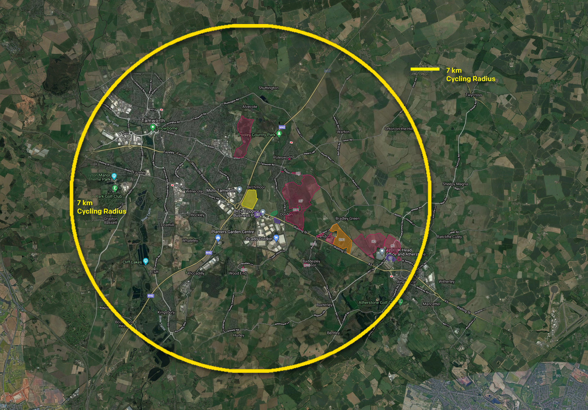
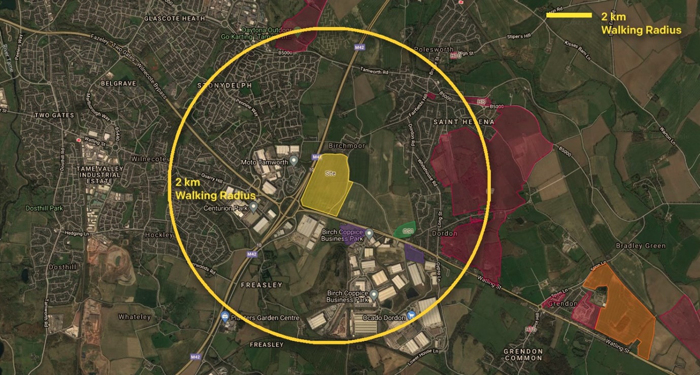
The cycling and walking plans demonstrate the site is easily accessible by foot (2km) and by bicycle (7km) from Polesworth, Dordon, Grendon, Baddesley Ensor, Birchmoor and Wood End, the majority of Tamworth, Atherstone and all of the major residential site allocations. The site can therefore attract a substantial local workforce whilst promoting more sustainable modes of transport for commuters and reducing impact on the local/strategic road networks.
Sustainable modes of transport – new proposals to encourage use
The key aims of the sustainable transport and highways strategy would be achieved through implementation of the following measures:
- Over 3.5km of new and enhanced public footpaths, bridleways and footway/cycleway routes, linking the site with Birchmoor to the north and Dordon to the east, and opening up foot and bicycle commuting opportunities from settlements further afield including Polesworth, Tamworth, Atherstone and all of the major residential site allocations;
- Provision of an enhanced bus stop to the south of the site on the east bound A5, providing a bus shelter with seating and segregated cycleway/footway;
- Cycle parking provided to all units in excess of the North Warwickshire design standards, incorporating a range of parking facilities to include indoor/outdoor secure and covered storage, all located at or close to the pedestrian entrances to each building;
- Showers and changing facilities provided to all units and communal cycle parking, showers and changing facilities provided at the ancillary hub office, available to the staff of all site occupiers;
- Preparation of a site wide Sustainable Travel Plan, setting out the commitment to promoting sustainable travel amongst all potential site occupants in order to minimise demand for car travel; and
- Contributions towards offsite sustainable transport enhancements.
New Public Rights of Way and cycle routes and improved existing Public Rights of Way and cycle routes
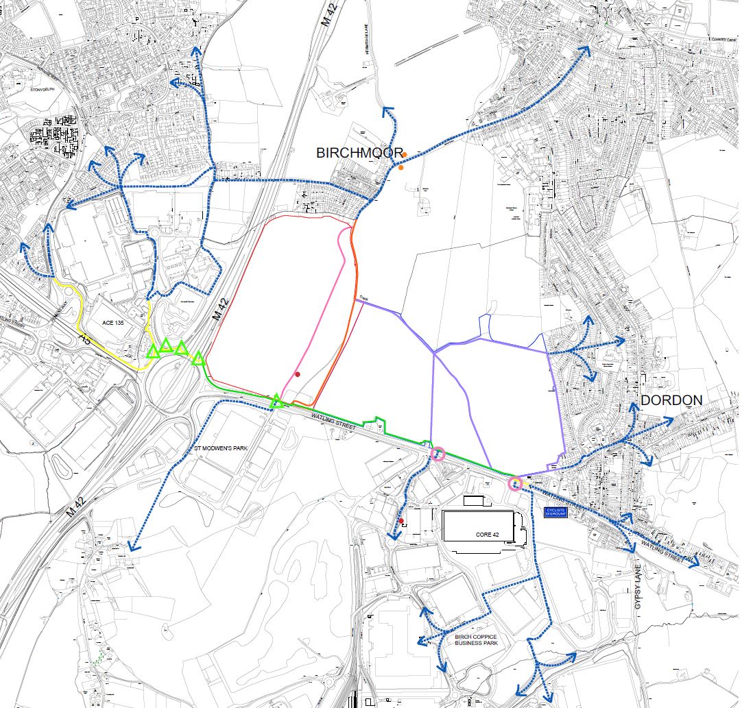
The proposed enhancements to the public right of way and footway/cycleway network in and around the site will improve pedestrian and bicycle permeability locally, allowing residents of Birchmoor, Polesworth, Dordon, Tamworth, Atherstone and all of the major residential site allocations to access the cluster of employment sites at Junction 10 M42 and to the south of the A5 more easily. As such, it is envisaged that these enhancements will make it much easier for employees in these locations to commute to work by bicycle or foot, leading to offsite sustainable transport benefits.
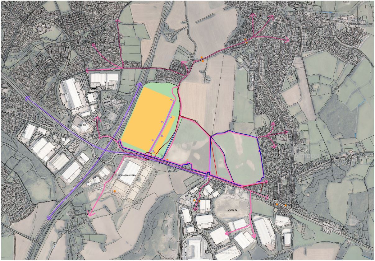
The Current Local Cycling Facilities Plan below shows that there is a lack of permeability from the existing residential areas north of the site through to the major employment centres in the area. This can be compared to the Proposed Accessibility Plan which has also been added below and illustrates the enhanced permeability that would be brought about by the proposals.
Current Local Cycling Facilities Plan

Proposed Accessibility Plan showing the improved permeability for cyclists and pedestrians for both commuting and leisure use
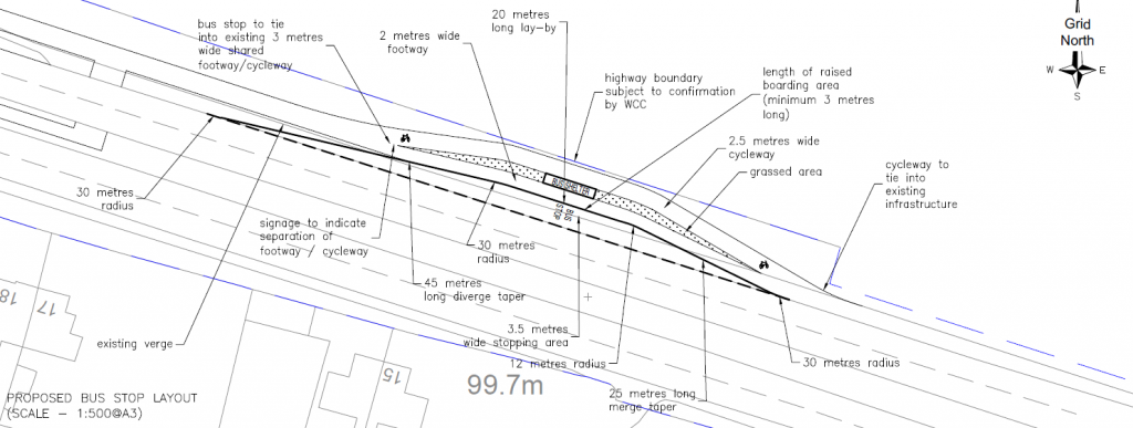
Proposed improvements to existing bus stop on the A5 and accompanying plan
Bus stop enhancement including provision of a covered bus shelter with seating capacity, associated street furniture, and segregated footway and cycleway all within 250m of the new site access.
New site access and accompanying plan
Specialist transport consultants have worked up proposals for a dedicated new access junction on the A5 following extensive discussions with the relevant highways authorities over the course of a number of years.
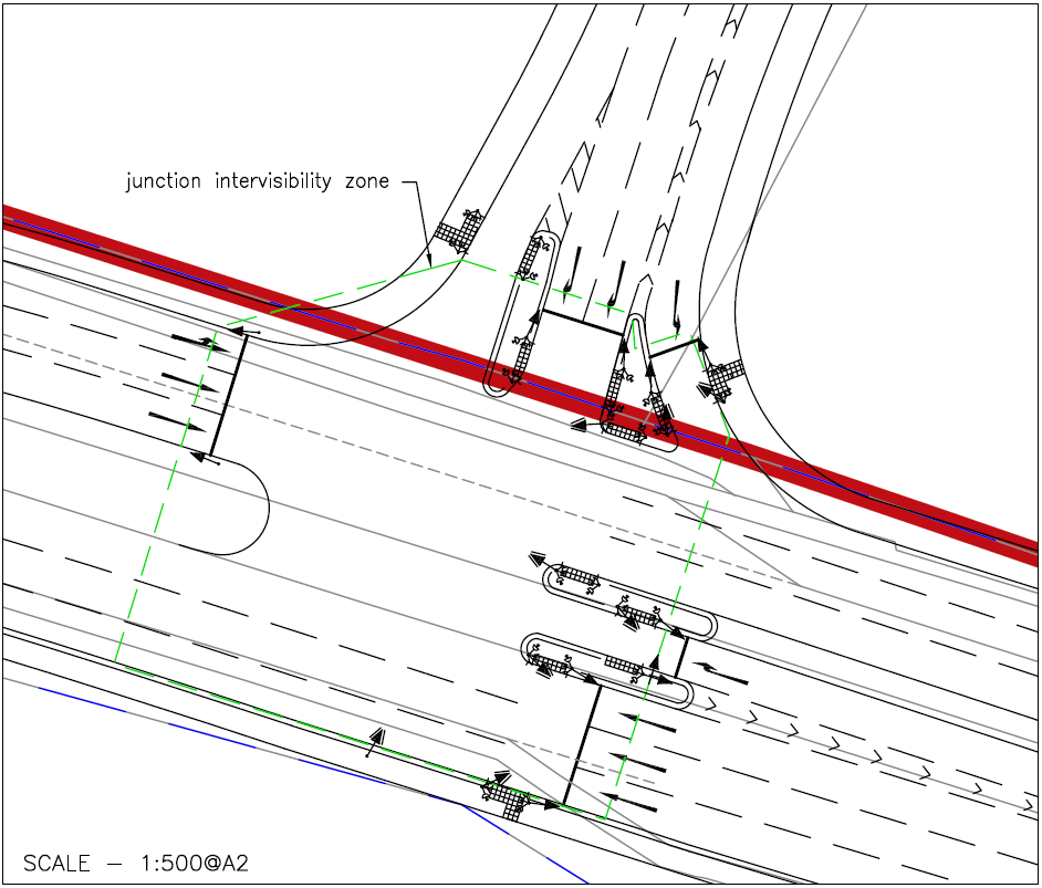
The proposed new access arrangement provides an enhanced fully signal controlled pedestrian crossing across the A5 in this location, which is a significant betterment on the existing crossing formed of a staggered gap in the central reservation. The proposed access junction would allow cycle and pedestrian commuters to cross the A5 to reach St Modwen’s Park and the public rights of way to the south of the A5.
The new access would also lead to the replacement of the existing laybys on the A5, which are currently used for adhoc HGV parking, with a purpose built secure facility with free parking, driver welfare and 24hr security within the site.
Discussions are ongoing with National Highways in relation to any offsite infrastucture improvements that may be necessary but the proposed access design incorporates enhancements to Junction 10 of the M42 motorway.
Rail-served site
Research undertaken has forecast that around 10% of loaded inbound and outbound traffic from the site could be expected to move by rail freight via Birmingham Intermodal Freight Terminal. Alone, that modal shift from road to rail would generate a significant carbon saving of just under 5,800 tonnes per annum. To put that into context, it is broadly the same level of carbon dioxide as that produced by around 2,750 typical mid-sized diesel powered cars during the course of a year, which is a further sustainability benefit of the development.